The preparation of Participatory Community Mapping and Customary Land-Use History is a critical process for community-based natural resource governance and the affirmation of land rights. It provides evidence demonstrating that specific areas have been customarily used since ancestral times. It also supports sustainable community development and helps reduce conflicts through the inclusive participation of communities and local authorities.
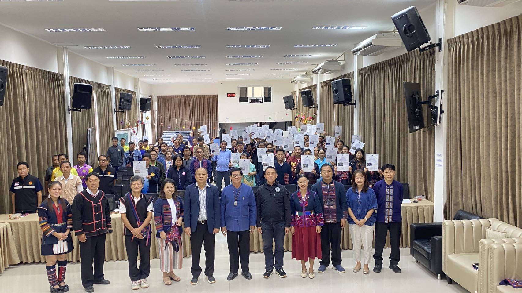
The (Upper) Mae Tam Watershed Network in Tha Kor Subdistrict, Mae Suai District, Chiang Rai Province—comprising 9 Indigenous communities, including Akha, Lahu, Karen, and ethnic Chinese—collaborated with the Tha Kor Subdistrict Administrative Organization, the Royal Forest Department, and the Royal Project Foundation to organize an information-sharing forum on the results of Participatory Community Mapping and plot-level Customary Land-Use History documentation with the communities of the Mae Tam Watershed Network. The forum also discussed the application of community regulations and governance mechanisms for co-management of land and natural resources at both the community and watershed network levels.
Mr. Manop Bunyuenkun, Chair of the Mae Tam Watershed Network, stated:
“The primary goal of developing this community-based dataset is to safeguard watershed forests in a manner recognized by all stakeholders, including communities, government agencies, and civil society partners. Documenting customary land-use history establishes the duration of land use, the types of activities undertaken, and how the land should be sustainably developed further. After more than a decade of advocacy, today marks an important milestone to inform all parties of the direction forward and ensure that all relevant government agencies understand and collaborate in the development process.”

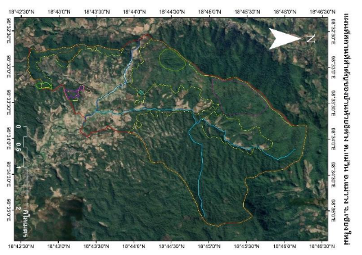
The Mae Tam Watershed Network has piloted Participatory Community Mapping in all nine Indigenous communities for over a decade, leading to the formation of the watershed network. The Network has also verified historical evidence by comparing satellite imagery prepared under the Royal Forest Department’s procedures from 2002 to 2014. Throughout the process, participatory collaboration between communities and relevant government agencies was emphasized—from field boundary surveys and data verification to community assemblies and public hearings.
Mr. Santhan Chaidech, Tha Kor Subdistrict Chief (Kamnan), explained:
“This mapping process enables relevant government agencies to clearly identify forest areas, agricultural land, villages, and other important sites, including their exact boundaries. This clarity allows communities to coexist with forests and prevents additional encroachment. It strengthens co-governance with local government agencies—such as the Forest Protection Unit, the Royal Project Foundation, and the Watershed Management Unit—and strengthens forest fire and haze monitoring. Villagers have cultivated this land for generations. In the past, conflicts occasionally occurred, but now they are resolved through the availability of participatory mapping data and customary land-use history documentation. Although this documentation may not yet have formal legal effect, it significantly improves clarity in land management with support from IMPECT and partner organizations.”

Similarly, Mr. Ratchanapong Rattana, President of the Tha Kor Subdistrict Administrative Organization, emphasized that Participatory Community Mapping and Customary Land-Use History documentation reduce land conflicts and strengthen collaboration:
“Most households in Tha Kor Subdistrict forest preservation and national park areas, with customary land-use histories passed down through generations. Cooperation and solidarity are essential for effective governance. When new policies arise, government officers must understand local communities and exchange information to ensure sustainable collaboration.”

Regarding the origin of Participatory Community Mapping initiatives, Mr. Kochi Phetphraipanawan, Mayor of Ban Luang Subdistrict Municipality, explained:
“Ban Luang Subdistrict Municipality began this effort after severe conflicts between lowland and highland communities. These conflicts, fueled by extensive forest fires and water scarcity, led to strong protests by lowland villagers, including blocking roads to prevent access. Highland residents were accused of destroying forests, causing fires and water scarcity. Protests occurred in Chiang Mai and Bangkok. It became clear that local communities must manage their own affairs because government-led management did not match local needs due to limited understanding of community contexts. Communities therefore consulted with relevant agencies for support. The Municipality issued local regulations and held public hearings, enabling Participatory Community Mapping and Customary Land-Use History documentation. After these processes, conflicts gradually eased and eventually disappeared due to cooperation among government agencies, the Royal Project Foundation, and the District Agricultural Office. The mapping information now supports co-management and improves the efficiency of local authorities. The next step is to integrate this data with the Land Development Department for land taxation management to support local communities and contribute to national development.”

Meanwhile, Mr. Thanandorn Homnan, Head of the Mae Suai Forest Protection Unit—the main authority responsible for natural resource management in Tha Kor—attended the forum and expressed support:
“In the past, villagers were often arrested; however, we now prioritize cooperation in wildfire suppression and forest restoration. Whether the data is accepted depends on the intention behind its preparation, and the communities have shown good intentions. Given the history of land conflicts Clear documentation from Participatory Community Mapping and Customary Land-Use History is beneficial for resolving land conflicts. The Forest Protection Unit operates with limited staff and budget, making it impossible to monitor the entire subdistrict. These maps therefore significantly enhance the Unit’s operational capacity.”
Finally, Ms. Nittaya Earkanna, Executive Director of the Inter-Mountain Peoples Education and Culture in Thailand Association (IMPECT), in her capacity as a partner organization supporting Participatory Community Mapping and activities that foster mutual understanding, emphasized that the core objective of this initiative is the affirmation of Indigenous Peoples’ rights.
“The developmen of community-based datasets for natural resource governance and Customary Land-Use History mapping can be useful and extended to the declaration of protected areas under the Act on the Protection and Promotion of Ethnic Groups’ Way of Life, which is a law advocated by Indigenous Peoples. That law, in particular, Article 9, recognizes the rights of indigenous people in the forest areas: that indigenous people have the right to land, natural resources, and the environment necessary for Indigenous livelihoods. Communities in the Mae Tam Watershed Network obtaining strong databases and good governance practices, can be protected and supported through co-management with government agencies”

The key principle is the co-management of participatory customary land-use mapping data and environmental resources between communities, the watershed network, and local agencies. Such collaborative governance leads to sound environmental management and clarity in land and natural resource governance, contributing to the development of a clear and useful database. However, sustainable management cannot be achieved if communities do not continue to enforce community agreements. Local government agencies must apply this dataset in environmental and land governance and establish monitoring systems to track changes in land use, landholders, and biodiversity through research-based assessments with clear indicators. These measures are essential because environmental stewardship benefits not only present needs but also future generations.